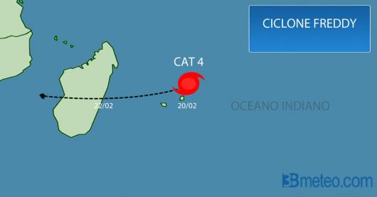
Tropical Cyclone Freddy is approaching Madagascar bringing torrential rain, flash floods, damaging winds and life-threatening conditions
Febbraio 20, 2023
Tropical Cyclone Freddy was formed over the Indian Ocean during the first days of February and quickly gained strength, reaching 250-260 km/h, a Category 5 on the Saffir-Simpson Hurricane Wind Scale, on Sunday 19/01/2023 close to Mauritius. Today is passing through Mauritius and Réunion as tropical cyclone Category 4 with sustainable winds of 220-240 km/h. A red alert for the state of Mauritius today as the authorities closed the international airport and Air Mauritius has already canceled 18 flights. Freddy has already brought earlier heavy showers to Mauritius and now is affecting Réunion.


Tomorrow, Freddy will land in Madagascar as a Category 3 or 4 with maximum sustainable winds of at least 200-210 km/h, while wind gusts can reach even 230-250 km/h. The central and southern parts of Madagascar will be affected more by Freddy with the southeastern and central-eastern regions, especially from Maharono to Manakara, experiencing the biggest risk for damages and flooding. Freddy is a severe tropical cyclone which is capable of destroying homes, infrastructures, crops and can also cause severe flooding.
The cyclone will continue its tear across the country during Tuesday and Wednesday, bringing new damages to some of the same areas that faced Tropical Cyclone Cheneso in January, which had brought flash flooding and damaging winds.
Rainfall accumulations could reach 140-200mm especially on Tuesday close to the regions of Mananjary and Fianarantsoa increasing the threat of damaging flooding. Coastal flooding will be also possible as the waves will reach 7-10m!

